Prestige Chapparakallu Road Location

Chapparakallu Road, called Chapparakallu Main Road in many listings, runs 5.65 km almost dead straight between two arterials of North Bengaluru's airport belt: the six-lane STRR (NH-648) at Chapparakallu in the north and IVC Road at Thindlu Circle in the south. It gives its name to Prestige Chapparakallu Road, an upcoming Prestige plotted development between the STRR and IVC Road. For anyone weighing Prestige plots near the airport in Bangalore, this short corridor packs in a great deal: Harrow International School and Amity University beside the highway at its northern end, the industrial area around the Foxconn plant just across it, and the IVC Road belt of registered Prestige plotted layouts beyond its southern end. Prestige Dalasagere is useful for the same-city location lens because the real test is weekday travel, school runs, healthcare access, and how the approach road feels at peak hours.

Status as at 21 September 2026. Prestige Chapparakallu Road is not yet registered with K-RERA, and no registration number has been issued. Prestige has not published an address, village or survey number for the launch, so every distance on this page is measured by road from the Chapparakallu junction on NH-648 or from the midpoint of Chapparakallu Road, never from a project gate. Do not pay a booking amount, EOI cheque or token against an unregistered plotted project; check the registration yourself at rera.karnataka.gov.in.

Prestige Chapparakallu Road Location at a Glance

ItemDetail
The roadChapparakallu Road (Chapparakallu Main Road), an existing 22 m major district road (MDR), two lanes today
Length5.65 km, from NH-648 at Chapparakallu to Thindlu Circle on IVC Road
Northern endNH-648, the Doddaballapur–Devanahalli section of the Satellite Town Ring Road (STRR)
Southern endIVC Road at Thindlu Circle, 5.6 km by road from the Chapparakallu junction
Villages along the roadChinna Kempanahalli, Kundana and Doddacheemanahalli to the east; Aluru Duddanahalli, Sulakunte and Dyavarahalli to the west
AdministrationKundana hobli, Devanahalli taluk, Bengaluru Rural district
PIN562110
Distances measured fromThe Chapparakallu junction (exact) and the road's midpoint (rounded)
Project addressNot yet published
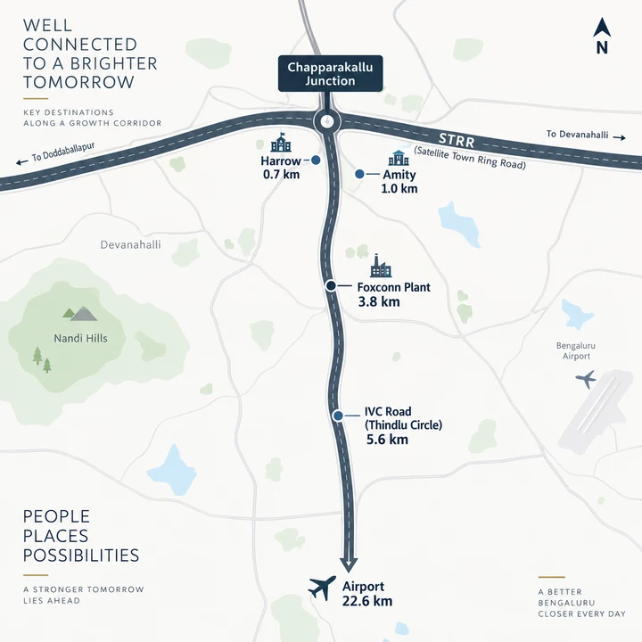
Prestige Chapparakallu Road location map along the Chapparakallu Road corridor near the Satellite Town Ring Road junction

Chapparakallu Main Road, End to End

Chapparakallu Road leaves NH-648 at Chapparakallu, the bus-stop locality on the highway, and runs 5.65 km almost dead straight south-south-west to Thindlu Circle on IVC Road. It is an existing 22 m major district road, two lanes wide today, and it passes between the Kundana-hobli villages rather than through them: Chinna Kempanahalli, Kundana and Doddacheemanahalli sit back from it to the east, and Aluru Duddanahalli, Sulakunte and Dyavarahalli to the west. Side roads branch east to Kundana and Devaganahalli, 2.6 km south of the STRR, and west to Aluru Duddanahalli and Dyavarahalli. On its southern half the road passes Cambridge Institute of Technology's North Campus. The shape of the road is its quiet advantage. Because it is short and straight, no point on it is more than about 2.8 km from one end or the other (half its 5.65 km length, our arithmetic). Wherever a plot sits along it, two arterials lie within reach in opposite directions, the ring road to the north and IVC Road to the south, plus whatever lane leads from the plot to the road. The name travels further than the road. Listings use both Chapparakallu Road and Chapparakallu Main Road, and the spelling shifts (Chaparkallu, Chapparkallu). When a plot is described as “on Chapparakallu Road,” ask which stretch is meant, and ask for the village and survey number.

The Northern End - NH-648 and the STRR at Chapparakallu

At Chapparakallu the road meets NH-648, the Doddaballapur–Devanahalli section of the Satellite Town Ring Road. Here the highway is six lanes, three each way, on an embankment, with service roads on both sides and an underpass linking them. Eastbound signs read “KIAL Airport Road”; westbound signs read “Doddaballapur; Gauribidanur.” The STRR's Doddaballapur bypass–Hoskote section has been open since 11 March 2024, so the ring road at this end of the corridor is working infrastructure, not a proposal. Two campuses stand beside the highway just west of the junction: Harrow International School Bengaluru, 0.7 km by road from the junction, and Amity University Bengaluru, 1.0 km. North of the highway lies the KIADB Devanahalli General Industrial Area, where the Foxconn plant stands; the plant's perimeter road is 3.8 km from the junction. The STRR is also the corridor's quick way east and west. Chapparakallu to Devanahalli is 11.8 km from the junction, east along the STRR to its interchange with NH-44 at Devanahalli. Chapparakallu to Doddaballapur runs the other way along the same highway: Doddaballapur railway station is 8.8 km from the junction, DMart Doddaballapur 9.9 km and Manipal Hospital, Doddaballapur 10.8 km.

The Southern End - IVC Road at Thindlu Circle

Chapparakallu Road ends at Thindlu Circle, 5.6 km by road from the junction, where it meets IVC Road, the Inter Village Connecting Road. IVC Road runs 8.7 km east from the circle to NH-44 (Ballari Road) at Daba Gate, near Devanahalli town. West of the circle, its continuation reaches Doddaballapur Road (SH-9). This is the IVC Road belt, home to Prestige's registered IVC Road plots. South of Thindlu Circle the same major district road carries on 8 km to Sir MVIT College Road near NH-44, and listings sometimes stretch the “Chapparakallu Main Road” name down that part too. A plot described that way may lie well south of the 5.65 km stretch this page describes, so its distances will differ from the ones below.

Is Chapparakallu Road Being Widened?

No widening scheme has been announced. Chapparakallu Road is a two-lane road today, within an existing 22 m width. The approved plan of a registered layout on the road reserves about 30 m for it, which keeps room for a wider road in future; a reservation of that kind is a planning line, not a scheme with a budget or a start date. Treat any claim that widening of Chapparkallu Road is under way as unconfirmed until a government notification says otherwise.

Prestige Chapparakallu Road Distances by Road

Two points anchor the corridor's distances. The Chapparakallu junction, where the road meets NH-648, gives exact road distances for that point. The midpoint of Chapparakallu Road, 2.8 km from each end, gives distances rounded to the nearest kilometre, because a plot could sit anywhere along the road. Neither is a distance from a project gate, and no drive times are given; the hour of travel decides those.
DestinationFrom the Chapparakallu junctionAbout, from the Chapparakallu Road corridor
STRR (NH-648)at the junctionabout 3 km
Harrow International School Bengaluru0.7 kmabout 3 km
Amity University Bengaluru1.0 kmabout 3 km
Foxconn plant, Devanahalli (perimeter road)3.8 kmabout 7 km
Cambridge Institute of Technology, North Campus4.2 kmabout 1 km
IVC Road at Thindlu Circle5.6 kmabout 3 km
Doddaballapur railway station8.8 kmabout 12 km
Vidyashilp University9.2 kmabout 6 km
DMart Doddaballapur9.9 kmabout 13 km
Manipal Hospital, Doddaballapur10.8 kmabout 14 km
NH-44 at Devanahalli (via the STRR)11.8 kmabout 15 km
Padukone-Dravid Centre for Sports Excellence12.7 kmabout 10 km
Stonehill International School13.0 kmabout 10 km
Prestige Tech Cloud15.0 kmabout 12 km
Kempegowda International Airport, Terminal 122.6 kmabout 19 km
Road distances on the OpenStreetMap driving network, September 2026.

Schools, Work and Everyday Needs Along Chapparakallu Road

Schools and universities. Education is the corridor's strongest suit. Harrow International School Bengaluru (0.7 km from the junction) and Amity University Bengaluru (1.0 km) sit at the northern end, Cambridge Institute of Technology's North Campus is about 1 km from the corridor, and Vidyashilp University (9.2 km from the junction) and Stonehill International School (13.0 km) are within reach. Work. The KIADB Devanahalli General Industrial Area begins across the highway, and the Foxconn plant's perimeter road is 3.8 km from the junction. Prestige Tech Cloud is 15.0 km from the junction, about 12 km from the corridor. Health and shopping. Doddaballapur is the nearest town for daily needs: DMart Doddaballapur is 9.9 km from the junction and Manipal Hospital, Doddaballapur 10.8 km. Sport. The Padukone-Dravid Centre for Sports Excellence is 12.7 km from the junction and about 10 km from the corridor.

Airport, Metro and Rail from Chapparakallu Road

Kempegowda International Airport's Terminal 1 is 22.6 km by road from the Chapparakallu junction and about 19 km from the corridor. The corridor figure is the shorter one because, from the middle of the road, village roads to the south reach NH-44 near the airport sooner than the STRR does. NH-44 itself is reached two ways: east along the STRR to the Devanahalli interchange, 11.8 km from the junction, or east along IVC Road from Thindlu Circle to Daba Gate. Namma Metro is still some way off. No operating metro station lies within 30 km by road; the nearest is Jalahalli on the Green Line, about 32 km away. The airport line's nearest station site, Doddajala, is about 12 km from the corridor, and the line is not expected to open before September 2027 (Deccan Herald, 20 August 2026). For rail today, Doddaballapur railway station is 8.8 km from the junction.

Registered Projects Near Chapparakallu Road

Chapparakallu Road sits among registered plotted layouts and established townships, each with its own public record to check.
ProjectAbout, from the Chapparakallu Road corridorStatus
Assetz City of Palms (Doddacheemanahalli)on the road itselfregistered plotted layout by a different developer, PRM/KA/RERA/1250/303/PR/300626/008780
Prestige Greenbrook (Singarahalli, IVC Road)about 4 kmregistered, PRM/KA/RERA/1250/303/PR/260925/008123
Prestige Crystal Lawns (Singarahalli, IVC Road)about 4 kmregistered, PRM/KA/RERA/1250/303/PR/300925/008132
Embassy Springsabout 7 kmtownship
Prestige Autumn Leaves (Hegganahalli)about 7 kmregistered, PRM/KA/RERA/1250/303/PR/240925/008116
Prestige Marigold (Bettenahalli)about 10 kmregistered, Phases I and II (PRM/KA/RERA/1250/303/PR/240122/004653 and PRM/KA/RERA/1250/303/PR/171225/008346)
Brigade Orchardsabout 18 kmintegrated township
Each project in this table is a separate development with its own registration and its own figures; none of them describes Prestige Chapparakallu Road, which is not yet registered. Any registration number above can be checked at rera.karnataka.gov.in.

What to Weigh on Chapparakallu Road

The corridor's trade-offs are few, and each is easy to check on a visit.
  • The address. The launch has no published village, survey number or address yet, so every distance here is a corridor figure. Ask for the survey number first.
  • The road. Two lanes today, with no widening scheme announced.
  • The metro. The nearest operating station is about 32 km away, and the airport line is not expected before September 2027.
  • Hospital and shopping. The nearest listed hospital and supermarket are in Doddaballapur, 10.8 km and 9.9 km from the junction.
  • Industry across the highway. The industrial area north of the STRR brings jobs and, with them, traffic; drive the junction at a weekday peak before you decide.
For what the plots cost, see the price page; for the sizes, the plot options page; and to join the priority list for launch details, the contact page.

Prestige Chapparakallu Road Location FAQ

Quick answers on where the launch is, the drive to the airport, whether the road is being widened, and metro access.

Where is Prestige Chapparakallu Road located?

Prestige Chapparakallu Road takes its name from Chapparakallu Road, the 5.65 km major district road that runs from NH-648 (the STRR) at Chapparakallu to IVC Road at Thindlu Circle, in Kundana hobli, Devanahalli taluk, North Bengaluru, PIN 562110. Prestige has not published an address, village or survey number for the launch, and the project is not yet registered with K-RERA. Distances on this page are therefore measured from the Chapparakallu junction and from the road's midpoint, not from a project gate. Ask for the survey number and village before you consider any payment.

Is Chapparakallu Road being widened?

No widening scheme has been announced. Chapparakallu Road is a two-lane, 22 m major district road today. The approved plan of a registered layout along it reserves about 30 m of width, which protects room for a wider road in future but is not a widening project. Treat any claim that widening is under way as unconfirmed until a government notification says so.

How far is Chapparakallu from Devanahalli?

From the Chapparakallu junction, the STRR runs 11.8 km east to its NH-44 interchange at Devanahalli. From the southern end of Chapparakallu Road, IVC Road runs 8.7 km east from Thindlu Circle to NH-44 at Daba Gate, near Devanahalli town. From the middle of the corridor, NH-44 at Devanahalli via the STRR is about 15 km by road.

How far is Chapparakallu Road from Kempegowda International Airport?

Terminal 1 of Kempegowda International Airport is 22.6 km by road from the Chapparakallu junction and about 19 km from the Chapparakallu Road corridor. The corridor figure is shorter because village roads south of the midpoint reach NH-44 near the airport before the STRR does. Drive times depend on the hour, so time the trip yourself on a site visit.

Is there a metro station near Chapparakallu Road?

No operating Namma Metro station lies within 30 km by road; the nearest, Jalahalli on the Green Line, is about 32 km away. The airport line's nearest station site, Doddajala, is about 12 km from the corridor, and the line is not expected to open before September 2027 (Deccan Herald, 20 August 2026). Doddaballapur railway station, 8.8 km from the Chapparakallu junction, is the nearest rail option today. Residential @ The Prestige Place is useful as a Prestige Group portfolio reference because the developer context carries across markets while commute, pricing, and possession still need local due diligence.

Talk to the Prestige Chapparakallu Road team

Request the corridor drive, the plot-availability details and the cost sheet as they are released. Join the priority list and we will call you back to talk through plot sizes and timing.

Contact Us